The Framework of the Village
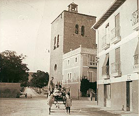
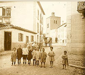
The village of Aoiz is located on the right bank of the Irati River and is situated to the north of the Lónguida Valley, at the base of the Zariquieta mountain range, 28 km from Pamplona. It is positioned within the geographical framework of the Lónguida Valley.
To the south of the village, the summit of Izaga (1,352 m) and the mountains of Gongolaz and Idoate stand out. From the plains of Aoiz, the horizon widens towards the west and southwest, providing open passage in both directions towards the Pamplona-Lumbier Basin.
The municipal area of Aoiz covers an area of 13.36 square kilometers and has an altitude of 504 meters at the core of the residential area.
The village is located in its center, on an alluvial terrace of clayey and sandy soils with a steep drop towards the river.
The Irati River, a key artery of the region, flows through the territory of Aoiz. It experiences a climate typical of the low mountains, sharing characteristics with the Pyrenean climate, especially in winter, which is cold and humid. Snowfall is much less than in the higher regions, and north and northwest winds prevail until the early months of spring. For a significant part of the year, up to mid-autumn, south winds dominate, bringing with them a dry and sunny climate. Temperatures range from a minimum of seven degrees below zero to a maximum of 36 degrees, with an annual average of 16 degrees.
The lands of Aoiz belong to a relatively recent period, the Eocene, and can be dated back to between 50 and 40 million years ago. This was a time of gradual regression of the sea in what are now continental areas, leading to the formation of the present-day landforms. These lands consist of various limestone formations, including blue marls and alluvial terraces.
Prehistory
During the Upper Paleolithic period, hunter-gatherer communities used the Pyrenean passes, resided in the northern area of Navarra, and ventured into the plains through the Irati and Salazar river basins. Their immediate successors during the Mesolithic period (8,000 to 3,000 BCE) began pastoralism and domesticated some of the species that are familiar to us today.
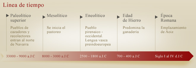
During the Chalcolithic period, the people known as the Pyrenean-Occidental, who are likely the ancestors of the Navarrese people, resided in our lands. They were primarily engaged in pastoralism and spoke a pre-Indo-European Basque language. Initially, they used caves for their dwellings, but later settled in strategic hilltop villages. This did not prevent them from practicing transhumance in tune with the seasons. This people, who formed the fundamental ethnic substrate of the Navarrese people and kingdom, have left numerous traces in the area we are discussing: caves along the banks of the Irati River with human remains and pottery, dolmens in Urraúl, Bigüézal, and so on.
From the late Bronze Age and throughout the Early Iron Age (8th to 5th centuries BCE), livestock farming prevailed over agriculture in our entire region. During the Late Iron Age, with the new Celtic immigrations of post-Hallstatt culture, agriculture took precedence in the Ribera and Zona Media regions, but not in this mountainous basin. Agriculture likely began in Aoiz around the 1st century BCE and continued to develop in the subsequent centuries.
The phenomenon of Romanization during the 1st to 4th centuries AD had a much deeper impact on the Ribera and Zona Media regions. The new socio-economic structures did not completely eradicate the indigenous Basque culture. Agriculture developed on large estates or “fundus,” and farming techniques saw significant improvements. At the same time, flatter lands were chosen for the placement of settlements, leading to the emergence of numerous villas and villages with Roman patronymic names, complemented by suffixes like “iz,” “oz,” “año,” “an,” “ain,” and “in.”
This period corresponds to the establishment of Aoiz, which, like many others, emerged due to the colonizing expansion of the towns in this region, including Liédena and Lumbier.
The Middle Ages
While shepherds and farmers were disputing the lands, in the year 408, the Suevi, Vandals, Alans, and other barbarian peoples arrived in the Pyrenees, ultimately bringing an end to the Roman Empire. At the same time, in the area we are discussing, the Basque rural element became predominant.
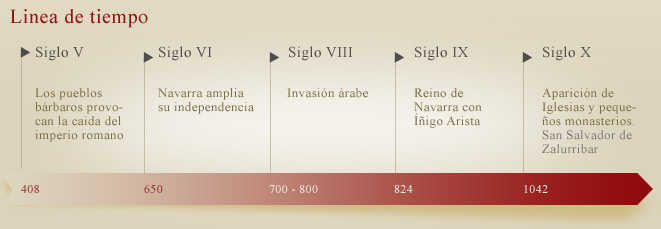
In the 5th and 6th centuries, our ancestors expanded their independence. By around 650, they advanced into the Ebro Valley, achieving the isolation of their entire territory. They preserved their ways of life and their distinct customs, laying the foundation for their first legal system or early charters (fueros).
From the late 6th century, they faced pressures from the Visigoths and Franks in the central and southern parts of Navarra. In the 8th century, the Arabs appeared, and despite their continuous raids, they failed to subdue the mountaineers. The ancient region of Sangüesa distinguished itself through efforts to maintain its independence. In the 8th century, the chroniclers began to refer to the southern Pyrenean Basques as Navarros for the first time. Among the indigenous leaders, mention is made of Jimeno el Fuerte and Galindo Belascotenes. The Jimeno family ruled in the Sangüesa area, while the latter, later displaced by the Aristas, governed in Pamplona. The quest for independence led to greater unity, culminating in the Kingdom of Navarre in 824 under Iñigo Arista.
The year 924 was disastrous for the independence cause because Caliph Abd al-Rahman III ventured into Navarre, rapidly punishing the villages and burning the crops on a punitive expedition. He came from Lumbier, along the right bank of the Irati River, and reached Aoiz, destroying everything in his path.
The eastern sector of our kingdom witnessed a flourishing revival of previously existing monasteries in the 9th century, promoted by a Carolingian influence coming from the other side of the Pyrenees. Due to this influence, new rural churches and small monasteries began to appear throughout the 10th century.
Among these, there is the Monastery of San Salvador de Zalurribar in Aoiz, located near the bridge on a narrow property along the left bank of the Irati River. It was probably the first religious center in this area. It belonged to the royal patrimony, and in the year 1042, King García IV of Nájera granted it to Fortún López, who in turn gave his own horse named Ozzaburu (according to Moret, “cold head”). On the occasion of the consecration of the Basilica of San Salvador de Leyre on October 27, 1057, Fortún López donated this monastery to Leyre, as recorded in the ancient and minor Becerros (registers) of Leyre under the name Zalurribar.
Late Middle Ages
In the Late Middle Ages, until the end of the 11th century, Navarre was primarily organized in a military fashion. Each region or area was under the command of a military leader, owing to the need to defend against potential Moorish attacks. Aoiz was under the command of Sancho Sánchez, Count of Erro, who had ties to the Navarrese royal family.
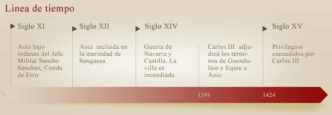
From the 12th century onward, these structures became more flexible, and the Merindades or merinas (named after each one was overseen by a merino) of the Montaña, Sangüesa, Estella, Tudela, and Ultrapuertos (The Merindad of Ultrapuertos, annexed to France in the 16th century, was referred to as the sixth Merindad from 1407. Today, it is known as Lower Navarre or Benabarra, with its capital being Saint-Jean-Pied-de-Port). The Merindad of the Montaña was also called the Merindad of Pamplona, after the kings acquired jurisdiction over the city in 1319. In 1407, Charles III the Noble created the Merindad of Olite, separating several towns from the Merindad of Tudela.
Aoiz became part of the administrative organization of the Lónguida Valley and the Merindad of Sangüesa. Following the abolition of the Tribunal de Comptos and the creation of Judicial Districts in 1835, Navarre was divided into 5 districts, corresponding to the boundaries of the historical Merindades, except for Sangüesa, whose capital was moved to Aoiz. This change was attributed by some to its favorable geographical position and by others to its role in the Carlist War. The town of Olite was designated as the capital of Tafalla.
In July 1362, the farmers of Aoiz and those from the Arce Valley were exempted from going to war against Aragon by paying 42 pounds of “carlines prietos” (a type of currency). The war against Castile, which was disastrous for Navarre, was equally devastating for Aoiz, as the Castilians set the town on fire. Only the tower of the Romanesque church was spared. Inside the church, the notary and clavero (a high-ranking official) Semén Sánchez de Aoiz had stored 40 cahíces of oats, which were part of the monarch’s tribute, and these were consumed by the flames without Carlos II demanding their replacement. In January 1379, September 1385, and August 1386, Carlos II visited Aoiz, issuing several documents and grants during his visits.
Carlos III, the son and successor, showed benevolence towards the residents of Aoiz. In 1388, while he was present, he inquired about the exemption granted by his father from the payment of 70 florins to the privileged Franks of the town, prosperous merchants who were descendants of foreigners. In 1390 and 1395, he exempted the nobles, clergy, and farmers from paying a quarter due to the difficult times and damage caused by hail in the vineyards. On February 3, 1391, there is evidence that the cupbearer purchased 20 loads of wine in Aoiz for the king’s table.
In 1391, upon the request of the council of Aoiz, Carlos III granted the territories of Guenduláin and Equíe to the town, which had been depopulated due to the Black Plague. The condition for this grant was the payment of five cahíces annually. The old hermitage of San Román, located to the south of Aoiz and adjacent to Aós, belonged to Guenduláin. In the Comptos Section of 1800, it is mentioned: “Depopulated Guenduláin and Equíe, as in 1534, with no buildings.” Despite this clarification, the hermitage of San Román has persisted to this day.
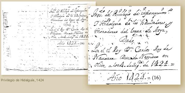
On September 4, 1424, the same noble King Carlos III favored the residents of Aoiz with a special privilege in recognition of their loyalty during the wars, where they defended themselves with great effort against their enemies. He decreed that they be considered as “infanzones” (nobles), “hijosdalgos” (hidalgo sons), “francos” (free men), and “quitos” (exempt) from all royal and imperial servitude, just like other privileges in the Kingdom. Juan II confirmed this grant in 1429.
The “Libro de Fuegos” of the Merindad of Sangüesa from 1428 contains more detailed information. Aoiz is listed at the head of the towns in the mentioned valley. The population census included three jurors, 50 residents or families, of which 12 were nobles (hidalgos), and 8 were impotent individuals. The vicar was Don Pedro Périz de Roncesvalles. Additionally, there were six clerics-beneficiaries, two of whom were abbots of Zazpe and Larrángoz.
Although logically, the census of 1428 should have exceeded that of 1366, the mortality around 1400 had caused 46 families to disappear. Witnesses testified before the king’s delegates that they paid an annual tribute of 117 cahíces of wheat. It was stated that they collected bread and wine for their provision and that there were communal mills. To support their livestock, they had to purchase supplies, as they did not rely on herb profits.
Flourishing
The second half of the 15th century was a period of affliction for Navarre. The civil war between Don Carlos, Prince of Viana, and King Juan I of Navarre and II of Aragon, sowed our geography with strife and death. The Beaumontese supported the Prince’s cause, while the Agramontese fought in favor of Don Juan, who, upon the death of Queen Doña Blanca, refused to place his eldest son Carlos on the throne, nor did he do so upon Carlos’s death in 1461 for his cousin Doña Blanca, or from 1464 for Doña Leonor.
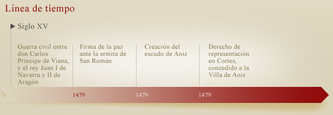
Pamplona and most of the mountain valleys were loyal to the Prince. The same happened in the Lónguida Valley, but not in Aoiz, which remained loyal to Don Juan. Don Carlos had visited Aoiz in 1442, and it seems that Don Juan did so in 1450, already in the midst of the conflict. Other personal interests, noble pretensions, selfish motives, factional struggles, etc., soon joined the initial cause of the conflict. The fighting continued until the deaths of Don Juan and his daughter, Queen Doña Leonor, who reigned in practice from January 28 to February 12, 1479.
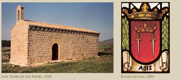
The beginnings of peace brought hope to the entire kingdom, especially to Aoiz. Princess Doña Magdalena, the mother and regent of the young King Francisco Febo, gathered the principal leaders of the Agramontese and Beaumontese factions in the vicinity of our town. In the presence of the princess, they drove their swords into the ground as a sign of peace. It is commonly asserted that this scene took place in front of the hermitage of San Román. The peace was signed by Marquess Don Pedro de Navarra on behalf of the Agramontese and Count of Lerín, Don Luis de Beaumont, on behalf of the Beaumontese.
Doña Magdalena dispatched seven documents dated September 17, 1479, one of which held special significance for the town where the peace had just been signed. Recognizing the general peace that was established in Aoiz after 30 years of conflict, she granted this town the title of “Buena Villa” (Good Town) with representation in the Cortes (parliament), and its residents were exempted from serfdom, whether they were ruanos (commoners), free men (francos), or exempt from any servitude. They were granted the privilege of having a perpetual admiral and a mayor, either perpetual or elected annually according to the will of the residents. Additionally, they were given permission to hold a market on the first Thursday of each month and annual fairs during the celebration of San Miguel.
In the General Archive of Navarre, another document is preserved, signed in Pamplona on January 16, 1480, by Cardinal-Infante Don Pedro de Foix, the viceroy or governor of the Kingdom and the brother of Doña Magdalena. Among other things, it states: “Considering that, through divine grace, the peace and repose of this kingdom were treated, concluded, and signed in the town of Aoiz,” he appoints Pedro de Balanza as the first Admiral of Aoiz. Pedro de Balanza had distinguished himself in services rendered to the king and the princess. This appointment was ratified on August 18, 1489, by King Don Juan de Albret and Queen Doña Catalina. In 1494, they elected a mayor from a list of three candidates proposed by the town.
With all these concessions, Aoiz separated from the administrative organization of the Lónguida Valley, gaining greater administrative and judicial autonomy in line with its new status as a Villa.
The coat of arms of Aoiz dates back to 1479 and is represented as follows: a gold crown rising between two silver swords adorned with gold, set against a red (gules) background. The red color, or gules, symbolizes aid and protection to the weak and subordinate, as befits good personalities and worthy authorities. The other elements of the coat of arms refer to the peace treaty between the Agramontese and Beaumontese factions mediated by royal authority.
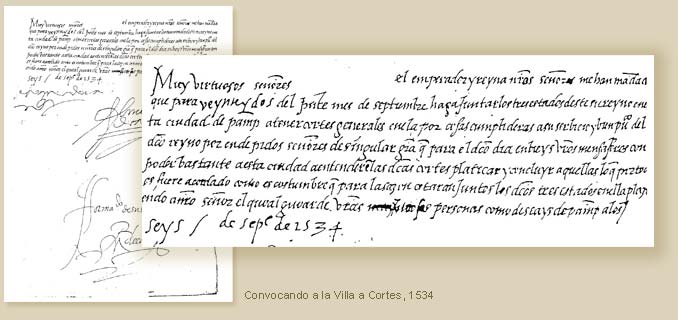
The right to representation or a seat in the Cortes, granted to the Town of Aoiz within the Universities’ branch in 1479, was exercised regularly and diligently by the designated representatives or deputies. On January 22, 1494, the kings of Navarre determined the seat to be occupied, and they were assigned seats next to those of Lumbier, which they continued to use without opposition. In the same Cortes of 1494, the representatives of Aoiz and other towns, in light of the absence of many municipalities despite repeated calls, stated, “We will not understand joining those who have voluntarily separated from us.” In the Cortes of 1504, when several procurators were absent once again, the representative of Aoiz was present. Regarding the distribution of expenses for the visit of the kings of Lower Navarre to Pamplona, it was agreed not to obligate Aoiz to pay more than their fair share.
In the Cortes of 1525, the town is ranked 12th. In the Estella Cortes of 1567, Aoiz, along with other towns, presented a proposal against the prohibition of hunting, which was detrimental to its privileges. In the Cortes of 1589, they raised another complaint, this time because the right of their representatives to sit after those of Lumbier had not been respected, as had been established. With determination and positive contributions, they participated in the Cortes of Navarre until the last ones in 1828-1829, during which they requested a weekly market for their town.
Modern Age
The initial milestone of the Modern Age in Navarre was the occupation of our land by the Castilian troops under the command of the Duke of Alba in July 1512, as ordered by King Ferdinand the Catholic. In an initial attempt at recovery, King Don Juan, with the help of the King of France, assembled a large army. Soon, several towns and valleys joined him, and they managed to besiege the city of Pamplona in November 1512. This army included Bearnese companies, which were defeated in the fields of Aoiz in early December by the Beaumontese troops under the Count of Lerín.
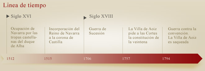
The Cortes of Castile, convened in Burgos in June 1515, decided to incorporate the Kingdom of Navarre into the Crown of Castile. After the reclamation attempts by Queen Catalina (1516) and her son Don Enrique (1521), tensions subsided. During the reign of the Habsburgs, Navarre experienced a notable resurgence in all aspects. It remained independent, with political, administrative, and judicial autonomy, retaining its legal constitution under the Foral system with its autonomous supreme bodies of the Kingdom. For more than three centuries, the Cortes of Navarre continued to convene, addressing the affairs of the kingdom and opposing the arbitrariness of the Castilian monarchs. In these Cortes, the various estates would swear loyalty to the Spanish kings, granting them titles and receiving them as their own. In turn, the monarchs and viceroys would swear to defend and improve Navarre’s fueros (laws and privileges). Additionally, Navarre continued to mint its own currency. The Spanish kings received their ordinal numbers in Navarre; for example, Charles I of Spain became Charles IV of Navarre, and Philip II of Spain became Philip IV of Navarre.
During the War of Succession, in 1706, Aoiz was asked to provide a list of people capable of handling weapons. The armies of the Grand Alliance, supportive of the Archduke, entered eastern Navarre, which remained loyal to the Bourbon claimant. In 1710, the people of Aoiz submitted a memorial reporting that the enemy had reached Gallipienzo. Shortly after, they approached the town and the nearby Urroz, but they were later repelled through the action of the Count of Melún.
Until the year 1757, the open council system, where all the residents had a voice and a vote, persisted for municipal administration. In that year, the town requested the establishment of the “veintena” (a group of twenty individuals responsible for local governance), which was subsequently established.
In the 17th century, there was no notary or registry office in the town, although there were two in Sangüesa, two in Lumbier, and one in Arce. By the late 18th century, there is a record of one in Aoiz, which gained significant importance when the town became the head of the judicial district. Extensive series of notarial records from various offices in this region were archived. In 1975, they were organized and transferred to the corresponding archive in Pamplona, except for those from the last hundred years.
In 1790, Aoiz, Sangüesa, and other valleys and towns in the region requested that the royal road be constructed through their area, immediately following the one from Logroño.
The war against the Convention marked the clash of two ideologies. The Navarrese fought heroically with a spirit of Crusade against the revolutionary forces that were enemies of the Altar, the Throne, and all traditions. Throughout the summer of 1794, the revolutionary army caused great devastation in the northern part of Navarre: they plundered towns, set churches and entire populations on fire, and committed murders of civilians, among other atrocities. They even reached Aoiz, where they used the same inhuman methods to steal, destroy, and take everything they could. Because of this, in 1797, the residents of Aoiz submitted a request to the Diputación (provincial government) seeking exemption from paying the donation tax for what they suffered during this war against France. The Diputación granted their request and exempted them from paying 1,428 reales. They received a similar grace in 1801, due to the damages caused by hailstorms and frosts.
Contemporary Age
At the cry of “The homeland is in danger“, patriots rose up en masse against the French invaders. In Madrid, one man with a surname originating from our town distinguished himself like few others: Luis Daoiz Torres.
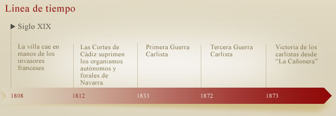
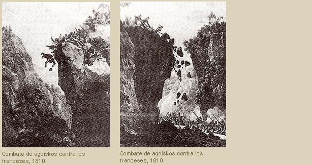
In November 1808, the Diputación (provincial government) issued a proclamation to the people of Navarre, inviting them to fight against the French because Religion, the King, and the Homeland were in danger. On behalf of the Diputación, the English general Doyle conducted a reconnaissance of the Aoiz-Lumbier area to prepare for resistance. Our town did not take long to fall into the hands of the invaders, who used an iron foundry to produce bombs and weapons.
Many residents of Aoiz voluntarily joined the Corso Terrestre led by Javier Mina. Those who remained in the town had to endure numerous hardships in all aspects of life. They were subjected to heavy monetary and food contributions, while civilians with family members in the guerrilla faced severe mistreatment and reprisals. Many were executed, imprisoned, or deported to France.
The Courts of Cádiz (1812) and the Constitution of 1820 advocated a liberal, revolutionary, and anti-foral ideology. They decreed the suppression of the autonomous and foral bodies of Navarra, disregarding the history and rights of the old kingdom. The Spanish Courts of 1820 issued a decree-project on the provisional division of Navarra into seven judicial districts, one of them with its capital in our town. In 1821, José Beortegui was appointed judge of first instance for the district of Aoiz.
In 1835, with the establishment of the territorial audiencia (high court) of Pamplona and the five judicial districts of Navarra, the justice tribunals (Council and Court) that had been in operation until then were abolished. Due to its central location, Aoiz was chosen as the administrative center of the largest judicial district, whose boundaries, in general, matched those of the former merindad of Sangüesa.
The reasons behind the First Carlist War (1833-1839) cannot be solely attributed to the dynastic question of Carlists versus Isabelinos. There is a deeper ideological motivation at play, one that has affected Spain since the times of the French Revolution. Milestones in this process include the Cortes of Cádiz with its constitution and the subsequent royalist reaction. Navarre, being Catholic, traditionalist, and protective of its regional privileges, supported the cause of Carlos V and fought against the liberals and their revolutionary program. This program, despite its abundance of liberal rhetoric, was contrary to legitimate freedoms, religious ideals, and the legal regional institutions.
In January 1834, the director of the Orbaiceta arms factory, Colonel Bayona, who was an Isabelino, defended the factory. However, on the 17th of the same month, he surrendered to Zumalacárregui. This brilliant Carlist general, after gaining the support of Aezkoa at the end of the month, also drew our town into his cause.
At the end of the conflict, the law of 1841 was negotiated. Until then, the mayor of Aoiz was appointed by the viceroy from a list of three candidates proposed by the town. These candidates were chosen by drawing lots from among the eligible residents. This traditional norm ceased to exist due to the appointments of constitutional municipal councils in 1836 and the Municipal Organization Law of 1845. However, the town’s administrative autonomy remained intact under the regulations of the Provincial Council.
Since the beginning of 1863, the Property Register for the territory of this judicial district has been in effect in Aoiz. Around the same time, according to notes from Prince Luis Luciano Bonaparte, the town was among the populations with minimal use of the Basque language. In the first registration of properties in this register, there is an extensive list of place names, mostly in Basque. Almost all of them are still preserved today.
The Third Carlist War (1872-1876) began as a reaction to the 1869 constitution, which was the most liberal of them all. From the start of hostilities, liberal forces established themselves in Aoiz with various troop contingents. The account books of neighboring towns show a long list of provisions and financial contributions to the troops on both sides. Sometimes, it is noted that they had to deliver these quantities to the liberals by force. In our town, all of this data is missing because the Account and Proprietary book, among others, was burned in the house of the magistrate. Years later, the State imposed significant exactions for what had not been contributed earlier to the constitutional troops.
In 1873, the Carlists blockaded the town, placing their cannons on the last hill to the south of Autzola. Since then, that summit has been named La Cañonera. The fortunes of the liberal forces turned against them, and after the memorable victory of the Carlist general Pérula in Lumbier in the summer of 1875, the liberals had to withdraw from the area. In our town, the Carlist association La Caridad established a hospital, the fifth in importance of the 22 that operated to provide care for the wounded and sick.